
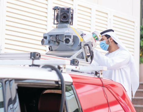
Dubai: Dubai Municipality has introduced a smart robotic system for geospatial surveying that uses LiDAR, cameras and 3D mapping technology to collect detailed information about buildings and infrastructure with limited human intervention.
The technology is designed to make field surveying faster, safer and more precise while helping the municipality maintain updated spatial databases used for infrastructure projects, asset management, urban planning and government decision-making.
The system can gather precise coordinates, panoramic imagery, video and three-dimensional data during surveying operations. By reducing the amount of manual fieldwork required, it can also limit the need for survey teams to work in difficult-to-access locations.
Robot delivers measurable results in Dubai housing project
Dubai Municipality said the technology has already been used at the Wadi Al Amardi Housing Project, where it supported final surveys of completed homes and the issuing of final survey certificates.
The deployment produced measurable efficiency gains. According to the municipality, it saved a combined 472 days of customer waiting time and reduced operating costs by 90 per cent.
Fieldwork was reduced by 24 days, while office-based work was cut by 40 hours.
The Wadi Al Amardi project is part of Dubai’s wider programme of housing developments for Emirati citizens. Earlier government announcements identified Wadi Al Amardi among areas selected for new homes under Dubai’s housing initiatives.
From conventional surveys to 3D mapping
The robotic system combines several surveying technologies to create a richer digital record of structures and assets.
Its outputs include panoramic imagery and highly accurate 3D point clouds, allowing surveyors to examine buildings and their façades in greater detail than conventional two-dimensional survey records.
The resulting information can be reused for subsequent engineering, planning and geospatial projects, reducing the need to repeatedly collect the same information.
Dubai Municipality said this shift toward detailed 3D data can improve the usefulness of survey information while supporting faster project delivery and more reliable decision-making.
Part of Dubai’s wider digital mapping programme
The robot is not an isolated technology project. Dubai Municipality has been developing a broader geospatial ecosystem around GIS, digital mapping and the emirate’s digital twin.
The municipality’s GIS Centre provides geographic and geospatial maps and data to government entities, businesses and other authorised users. Its systems include digital databases and mapping platforms designed to support planning, construction and management of city assets.
Dubai Municipality has also previously demonstrated robotic surveying technology. At GITEX Global 2024, it showcased a Robot Scanner capable of collecting and analysing geospatial survey data for government assets, including buildings, landmarks and infrastructure networks above and below ground.
The municipality has separately described its use of drones and a geospatial vehicle to update mapping data, create 3D information and support the development of Dubai’s Digital Twin.
What the technology means for Dubai’s urban planning
For Dubai, the value of robotic surveying extends beyond replacing manual measurements.
Accurate and frequently updated spatial information can help authorities understand the condition and location of buildings, infrastructure and other assets. Three-dimensional datasets can also provide a more detailed foundation for engineering, construction planning and asset management.
Dubai Municipality has said its geospatial information is used by decision-makers and other stakeholders to improve planning, productivity and the business environment.
The municipality’s existing Virtual Reference Station network also provides high-accuracy positioning services for surveying, construction, GIS and related applications across Dubai.
The latest robotic deployment therefore represents another step in the emirate’s broader shift toward automated data collection and digitally connected urban management.
What has Dubai Municipality introduced?
Dubai Municipality has deployed a smart robotic surveying system using LiDAR, cameras and 3D mapping technology to collect geospatial data with limited human intervention.
What does the Dubai surveying robot collect?
The system collects precise coordinates, panoramic images, video and three-dimensional data that can be used to maintain spatial databases and support planning and infrastructure work.
Where was the robot used?
It was used at the Wadi Al Amardi Housing Project to conduct final surveys of completed homes and support the issuance of final survey certificates.
How much did the technology reduce costs?
Dubai Municipality said the deployment reduced operating costs by 90 per cent at the project.
How much time did the robot save?
The municipality reported a combined saving of 472 days in customer waiting time, along with a 24-day reduction in fieldwork and 40 fewer hours of office work.
What is LiDAR used for in surveying?
LiDAR uses laser measurements to capture detailed information about the physical environment. In this application, it helps generate highly accurate 3D survey data and point clouds.
How does 3D mapping help Dubai?
Detailed 3D data can support engineering, urban planning, infrastructure management and the updating of digital records of buildings and other assets. Dubai Municipality is developing a wider geospatial ecosystem around such technologies.
Is Dubai using other automated surveying technologies?
Yes. Dubai Municipality has also highlighted drones, geospatial vehicles, digital mapping, AI applications and other technologies as part of its geospatial and digital-twin initiatives
